Analyzing Shifts in Territorial Control within Syria Offers Glimpse of Future Challenges
Nine years have passed since the conflict in Syria began. In recent months, as opposition strongholds have fallen and frontlines have shifted, the map of territorial control suggests that the conflict is entering its endgame.
A historical analysis of earlier territorial-control maps illuminates the full extent of more than nine years of war and hints at the effort needed to bring the fragmented nation together. Syrian communities – towns, villages, cities, and neighborhoods – have experienced the conflict in different ways, and even if major military operations cease, the conflict is far from over.
A Four-Way War
Four major sides have fought for control in Syria – the Syrian government and its allies, the conglomeration of groups known broadly as the opposition, Kurdish-led forces, and Islamic State. Each faction is made up of a variety of actors. For example, the Syrian government faction includes Russian and Iranian forces, and Shia militias, including Hezbollah.
At least 56% of Syrian communities (including neighborhoods of major cities) have changed hands at least once over the course of the conflict. Some communities have changed hands repeatedly as frontlines ebbed and flowed. Often, when a community changes hands, people are killed or injured, infrastructure is damaged, looting occurs, and new grievances are born.

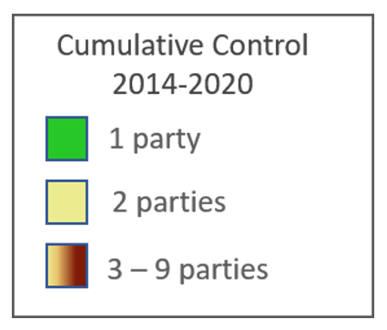
Figure 1: Cumulative month-by-month changes in armed group control of Syrian communities from Jan. 1, 2014, to April 1, 2020. Green communities have only been controlled by one party, yellow by two, with darker orange to red and black representing communities that have changed hands up to nine times. Lines show each community’s nearest seven neighboring communities. Graphic made using Gephi.
Since 2014, The Carter Center has documented territorial changes at the community level. By analyzing social media posts, reports from networks like the Syrian Observatory for Human Rights, and, more recently, the publicly available dataset provided by the Armed Conflict Location & Event Data Project, the Center has compiled snapshots of military control on a monthly basis for more than 8,000 locations throughout Syria.
The map above offers a color-coded look at how often each of the 8,087 locations in the Center’s database has changed hands. Given the many thousands of recorded territorial changes, and the time-consuming effort of verifying each of these reports, this map shows only changes in control from month-to-month. This approach means that back-and-forth changes that occur during each month are not reflected in the map, but ensures that those changes that are displayed are verified and accurate. To show colors, regions, and population density more clearly, each community is linked to its nearest neighboring communities.
Different Experiences with Conflict
Knowing which communities have had frontlines sweep through them, and how often, is important for understanding the movement of internally displaced persons, directing aid relief programs, targeting mine clearance activities, measuring conflict intensity, and more.
In the case of Syria, however, it is also important to understand which parties have fought over what territory. With four major factions at odds, Syrian communities have collectively experienced a staggering 14 different combinations of armed actor groups controlling their communities over the course of the conflict. This does not account for the different types of control exacted by varying armed actors within a group, such as the difference between control exacted by a nonstate militia made up of former smugglers and that exacted by the Syrian Arab Army.
Changes of territorial control often included hours or days of shelling or bombing from warplanes, leaving many towns damaged and civilians traumatized. When a new group took control of a territory, some left civilians alone while others brutalized civilians as the Islamic State did to the people of Raqqa city when it took charge there.

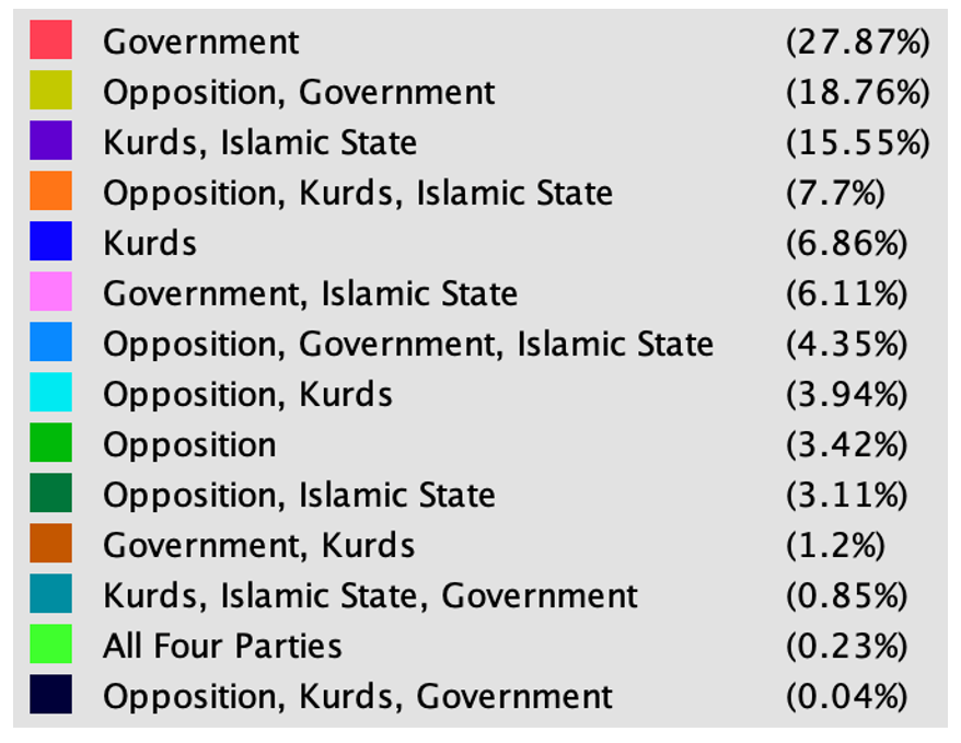
Figure 2: Syrian communities color-coded according to the different combinations of armed faction control they have experienced. Each community is linked to its seven nearest neighbors. Graphic made using Gephi.
Since 2014, when The Carter Center began its database of territorial control, 47% of Syrian communities have been controlled by two different armed sides, and 13% of Syrian communities have been held by a combination of three different armed sides. Nineteen communities have been controlled by all four major sides at one point or another.
The map above shows Syria’s communities color-coded according to the unique combination of armed actors that have controlled each. For example, pink points represent communities that have been controlled by both the Syrian government and the Islamic State, yellow communities have been split between the opposition and the government. Orange communities have been controlled by Kurdish-led forces, the opposition, and Islamic State, and so on.
Moving Forward
In recent months, conflict has re-emerged in southern Syria, despite Syrian government ostensibly having been in military control there for well over a year. This outbreak of violence is not new or random, but a reflection of more than nine years of division and grievances between communities. There has been an increase of protests, of armed groups attacking Syrian military checkpoints, and of IEDs use across the southern region. This is concerning because the south has not seen as many back-and-forth territorial changes throughout the years as have other regions. It could foreshadow what is in store for other parts of Syria in months and years to come as the government solidifies its territorial control.
With each passing year of the conflict, with each introduction of new conflict actors, the communities of Syria have been divided into smaller and smaller groups with their own unique experiences of the conflict. Children born during the crisis have grown up having never known a united Syria, having missed schooling, and in many cases having little shared experience with other Syrian children apart from the trauma of war.
Even if the fighting stopped tomorrow, it will take a long time for such a complicated conflict to truly end, and echoes of the divisions between communities will surely be heard for generations.
The first step to fixing any conflict is understanding it. While there is a long road ahead, the Syrian people’s efforts to document developments in their country (reflected in part in this report) will form one of the invaluable foundation stones on which peace can be built.
Learn more about the Carter Center’s Syria Mapping Project »
Global Impact Starts with You
Your support sustains the Carter Center's mission of waging peace, fighting disease, and building hope around the world.